Westmoreland, New Hampshire 03467
Westmoreland, NH Lodging, Real Estate, Travel & Visitor Information
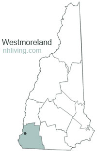
![]() Westmoreland, New Hampshire was once known as Great Meadows. The town was established in 1735 as Number 2 in the line of Connecticut River fort towns designed to protect the colonies from Indian attack. When New Hampshire became an independent province, it was granted to settlers as Westmoreland, named for John Fane, seventh Earl of Westmoreland. The meetinghouse in Westmoreland, built in 1762, has a Paul Revere bell. Westmoreland is borderd on the west by the Connecticut River which separates Vermont and New Hampshire.
Westmoreland, New Hampshire was once known as Great Meadows. The town was established in 1735 as Number 2 in the line of Connecticut River fort towns designed to protect the colonies from Indian attack. When New Hampshire became an independent province, it was granted to settlers as Westmoreland, named for John Fane, seventh Earl of Westmoreland. The meetinghouse in Westmoreland, built in 1762, has a Paul Revere bell. Westmoreland is borderd on the west by the Connecticut River which separates Vermont and New Hampshire.
To share any Westmoreland, NH information with us, please contact us. Learn more about advertising in NHLiving.
Incorporated: 1752
County: Cheshire
Westmoreland, NH Population:
2010: 1,874
GPS Coordinates:
Latitude: 42.5743
Longitude: -72.2632
Westmoreland, NH Local Information
Westmoreland Police Dispatch: 911

inns | hotels | resorts | rentals | attractions | dining | real estate
SUGGESTED MONADNOCK REGION NH LODGING Visit Monadnock Region NH Vacation Specials. Browse current Keene NH area vacation rentals, inns, resorts, and pet-friendly lodging availabilities below.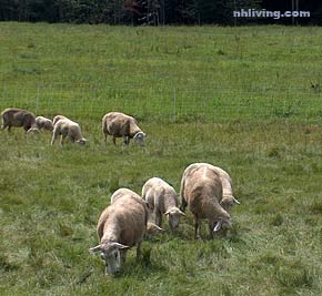
Westmoreland sheep
New Hampshire Towns
NH Lodging Guide | Weddings
Products | NH Town Guides
New England Living Magazine
Free World Mall
Country Weddings | New England Recipes
Paradise Coast Living | Boston Red Sox Gifts
Vermont Living | ME Living | MA Living